Loading...

Visualisation of wind turbines

Services in detail

Expert visualisations according to
good professional practice

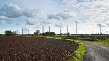
From regional priority areas to planned wind farm repowering, we visualise projects in photos, videos, panoramas or as virtual 3D models! The visualisations are developed by experts in accordance with good professional practice, which we helped to develop. They are therefore suitable as a basis for expert opinions, e.g. on the landscape or monument protection, the upcoming public relations work or the application for approval.

Animated rotors give the visualisations a much higher degree of realism. If a digital presentation or publication of the visualisations on the internet is planned, animated rotors can be an attractive addition. Wind farms can even be efficiently visualised in moving camera shots that, for example, pick up the perspective of a cyclist or car driver.

Day and night lighting
of wind turbines

Wind turbines must be made visible to air traffic control. There are two options: signal red markings on the mast, nacelle and rotors or flashing lights at certain points on the mast and nacelle. The requirements vary depending on the location and size of a wind turbine or wind farm. The variant of daytime lighting with red painted markings is usually shown in visualisations. We also simulate the flashing lights of night lighting for you.

Demonstration of acoustic and visual simulations
of planned wind turbines

In addition to the visual alteration of landscapes, the acoustic impact is often a concern for citizens and decision-makers. In the Dezent Zivil research project, a methodology was developed with the acoustics specialists from Möhler + Partner Ingenieure AG to realistically demonstrate the acoustic and visual impacts of the wind farm. The effort involved is relatively high, but most of the participating experts, citizens and decision-makers found the auditory experience a helpful complement to the visual simulation.

Early visualisation of priority areas

Especially in higher-level planning processes, visualisation should take place as early as possible! We have visualised the priority, test or potential areas for many regions without concrete locations for wind turbines being available. These visualisations help planners to evaluate individual areas and they inform the public in a neutral and technically sound manner. It is important that the first circulated visualisations are reliable and methodologically sound. These first images remain in the „visual memory“ and shape opinion and perception.

GIS-based visibility analyses
as an aid to site search

For large-scale and complex projects, it can be useful to calculate a visibility analysis in the GIS before selecting and visualising individual photo locations. This allows the problem areas in the landscape to be identified and examined in more detail. The selection of photo sites is more informed. The visibility analysis can be created directly in such a way that it also meets the requirements of the landscape conservation plan.